- Gridded data with GML metadata
- Enables interoperable access to detailed and rich geospatial data as “coverages”
- Supports Binary files: GeoTiff, HDF-EOS, CF-NetCDF, JPEG
-
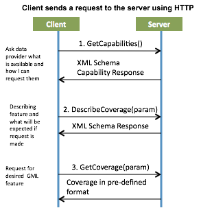
Provides three main Requests:
- GetCapabilities: Retrieves a list of the server’s ata, available Services, WCS operations, and parameters
- DescribeCoverage: Retrieves an XML document that fully describes the requested coverages
- GetCoverage: Returns a coverage in a well-known format with several extensions to support the retrieval of coverages
Like WMS, the WCS standard returns similar formats. In addition, WCS is capable of providing:
- valuable metadata and more formats
- multi-valued coverages
- more precise queries against multi-dimensional back-end formats
- raster data in form of “source code” with detailed descriptions of the map (unlike WMS raw static image)
- coverages that relate a multi-dimensional spatio-temporal domain to a range of properties (unlike WFS which returns discrete geospatial features)
WCS Examples
The following links are two example for GetCapabilities Request:
- Northern Hemisphere: http://nsidc.org/cgi-bin/atlas_north?service=WCS&request=GetCapabilities&version=1.1.1
- Southern Hemisphere: http://nsidc.org/cgi-bin/atlas_south?service=WCS&request=GetCapabilities&version=1.1.1
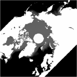
After requesting GetCapabilities and DescribeCoverage, the WCS Client can place a GetCoverage Request. The below is a GetCoverage REST request for A GeoTIFF of sea ice concentration at 25-km resolution in a polar stereographic projection focused on the Arctic (138 KB):
GetCoverage Response from Server:
Images: