OGC WMS standards serve visualizations of geographical data in “flat” map-like layered images. HTTP queries a WMS server and returns pre-rendered images from different sources.The returned images from different sources can be layered on top of each other.
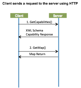
WMS Examples
The following links are two XML examples for GetCapabilities Request:
- Northern Hemisphere: http://nsidc.org/cgi-bin/atlas_north?service=WMS&request=GetCapabilities&version=1.1.1
- Southern Hemisphere: http://nsidc.org/cgi-bin/atlas_south?service=WMS&request=GetCapabilities&version=1.1.1
GetMap Northern Hemisphere request using the known parameters from GetCapabilities:
GetMap Response
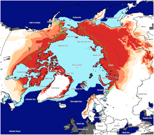
Images: