Open-source Project for a Network Data Access Protocol (OPeNDAP) is a data transport and protocol, based on HTTP, used by Earth Scientists. OPeNDAP specifies how to request a subset of a large dataset. It also specifies the over-the-network format for the response. The simplicity, flexibility, and efficiency of the protocol have led to its wide usage in the oceanographic and other scientific communities. There are many DAP compatible servers such as Hyrax, THREDDS, PyDAP, and ERDDAP. OPeNDAP servers manage large amounts of remotely sensed and model data, typically in grid formats such as NetCDF, GRIB, and HDF.
OPeNDAP can be used to:
OPeNDAP Response Types
OPeNDAP provides three basic data types, and Request to Client OPeNDAP will result in following three different requests for data to OPeNDAP Server:
-
Request for the Data Descriptor Structure (DDS): is a data structure to describe datasets and subsets of those datasets – Shape of Data
- Syntactic Metadata - Rigid
-
Request for the Data Attribute Structure (DAS): is a set of name-value pairs used to describe the data in a particular dataset
- Semantic Metadata - Flexible
- Request for actual Data (DODS): is data structure used by the DODS software to describe datasets
OPeNDAP Client-Server Architecture
|
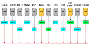
OPeNDAP Servers:
•CODAR
•netCDF
•HDF4/5
•Matlab
•DSP
•Tables (JGOFS)
•SQL (JDBC)
•FITS
•CDF
 |
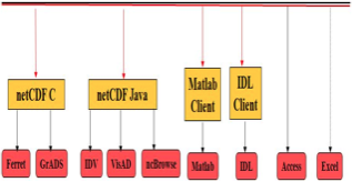
OPeNDAP Clients:
•Ferret and GrADS (netCDF C)
•IDV, VisAD, and ncBrowse (netCDF Java)
•Matlab
•IDL
•Access
•Excel
 |
OPeNDAP Services at GSFC
Currently, the GES DISC offers the datasets listed at http://disc.gsfc.nasa.gov/services/opendap/ through OPeNDAP.
For example, AIRS data are made available through http://disc.sci.gsfc.nasa.gov/gesNews/opendap_AIRS_data_access
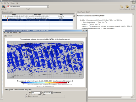
OPeNDAP Support of IDV, GrADS, and Panoply
There are a variety of tools and file formats used with Earth science data, including IDV, GrADS, and Panoply. In general, IDV and Panoply have the easiest learning curves while GrADS is somewhat harder.OPeNDAP allows for remote access of data at a sub-file level, making the data easier to use.
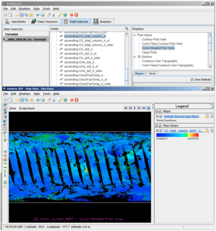
Tropospheric NO2 from OMI for July 7, 2010: http://acdisc.gsfc.nasa.gov/opendap/HDF-EOS5/Aura_OMI_Level3/OMNO2e.003//2010/OMI-Aura_L3-OMNO2e_2010m0707_v003-2010m0708t161138.he5
Other Examples:
Additional examples for Panoply and IDV, as well as examples for GrADS can be found at: http://wiki.esipfed.org/index.php/Making_Science_Data_Easier_to_Use_with_OPeNDAP