Other
ESIP Releases Fall 2017 Testbed Request for Proposals
Submitted by annieburgess on Tue, 2016-10-04 14:55The ESIP Products and Services Committee announces the October 2016 call for Testbed projects. Proposals may be submitted by any ESIP member, an individual within such an organization, or a team of such individuals. Civil servants are restricted from receiving ESIP funds.
Collective Impact: Reaching Across Boundaries in Climate Education
Submitted by johannambozuwa on Sun, 2016-09-18 05:40Collective Impact: Reaching Across Boundaries in Climate Education
Over the past few months, the Climate Literacy and Energy Awareness Network (CLEAN) has been ramping up discussion about how we can effectively scale change in climate literacy through collective action.
Connecting Communities: identifying synergies between international integration initiatives
Submitted by hsu.leslie on Fri, 2016-07-15 08:51Do you find yourself calling in to multiple working groups on the same topic, for example, Semantics? Data Rescue? Data management and preservation? Do you feel like you live in a universe where you discuss your favorite research topic on monthly or biweekly GoToMeeting or WebEx calls?
Droning the Castle Hill Rock Formation and Building 3D Models with Photoscan & Drone2Map
Submitted by Sean_Barberie on Sun, 2016-07-10 09:34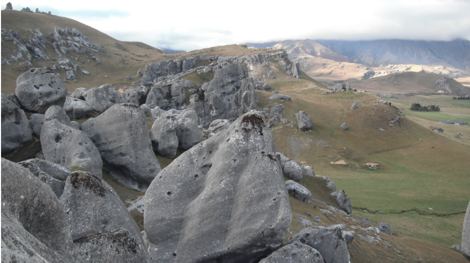 This blog entry is part 2 of a short series on my recent research trip to New Zealand. Here I show the data collection and construction of a Structure-from-Motion 3D model of the Castle Hill rock formation. I use both Agisoft Photoscan and ESRI ArcGIS Drone2Map for the data processing. Come back soon for a post on placing seismometers on Tasman Glacier and collecting drone imagery of the terminus, and a post on science of opportunity and building models of glacial lake icebergs.
Using a drone to build 3D Structure-From-Motion models in New Zealand, Part 1: Evangelizing drones for science
Submitted by Sean_Barberie on Mon, 2016-06-06 13:25This blog entry is part 1 of a short series on my recent research trip to New Zealand. Here I show a rough test case of building Structure-From-Motion models using imagery from a DJI Phantom. Come back soon for a post on using Structure-From-Motion on the Castle Hill rock formation, a post on placing seismometers on Tasman Glacier and collecting drone imagery of the terminus, and a post on science of opportunity and building models of glacial lake icebergs.
Small Aircraft and Big Data: Meet Sean Barberie
Submitted by Sean_Barberie on Fri, 2016-03-04 17:55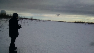
My name is Sean Barberie and I'm a second year ESIP student fellow working with the Disaster Lifecycle Cluster. In my day-to-day research I work with drones and the huge amount of data they generate. This is my hello world post so you can learn a bit more about me.
Climate Interactions with Ecosystem Structure & Function: Meet Chris Beltz

Hello World! My name is Chris Beltz and I am a 2016 ESIP Student Fellow working with the Agriculture and Climate cluster. I am a second-year PhD student in Ecology at the University of Wyoming.
Member Highlight: NASA Earth Observations
Submitted by annieburgess on Tue, 2015-11-17 16:00![]()
NASA Earth Observations (NEO), celebrating its 10th anniversary in 2015, is a system that delivers global imagery of NASA Earth science data. The system was developed to meet the needs of an audience that has a desire to use images of NASA data but does not have the expertise or tools to locate, download and process the data themselves.
Agriculture, Climate and Water: Can Drones Help Us Make Better Management Decisions?
Submitted by Lindsay.Barbieri on Wed, 2015-10-21 14:52Flinging a small fixed-wing drone into the crisp morning air to monitor an agricultural field, the whine of the propellers gives way to a burst of radio chatter.